


 Patuakhali District-
Patuakhali District is a prominent coastal district in the Barisal Division of southern Bangladesh. Often referred to as the “Gateway to Kuakata Sea Beach”, the district is renowned for its rich river network, scenic coastal views, fertile agricultural lands, and growing significance in the tourism sector. Due to its strategic location and natural resources, Patuakhali plays a vital role in both regional and national development.
Geographic Location-
Patuakhali is located in the southern part of Bangladesh, with coordinates between 21°48′ to 22°36′ north latitude and 90°08′ to 90°40′ east longitude. It shares borders with Barisal and Jhalokati to the north, the Bay of Bengal to the south, Barguna to the west, and Bhola to the east.
- Total Area: 3,220.15 sq km
- Major Rivers: Tentulia, Lohalia, Andharmanik, Galachipa, Agunmukha
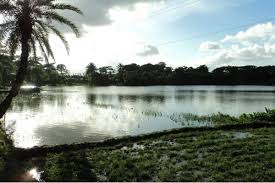
Its close proximity to the Bay of Bengal makes it vulnerable to natural disasters like cyclones and tidal surges, but also endows it with a marine ecosystem rich in biodiversity.
History-
The history of Patuakhali dates back to the Mughal era, when it was part of the Bhati region of Bengal. It gained importance as a trade and riverine transport hub under British colonial rule. Patuakhali was declared a subdivision under Barisal District in 1867 and became a full-fledged district in 1969. Since then, it has evolved into a key coastal region with rapid socio-economic progress.
Administrative Divisions-
Patuakhali District is divided into 8 Upazilas:
- Patuakhali Sadar
- Dumki
- Mirzaganj
- Galachipa
- Dashmina
- Bauphal
- Kalapara
- Rangabali
These upazilas are further divided into unions, municipalities, and wards, each playing a crucial role in local administration and service delivery.
Population and Demographics-
As per the latest census, the total population of Patuakhali District is approximately 1.6 million. The majority are Muslims, followed by Hindus, and small groups of Buddhists and Christians.
- Religion:
- Muslims: 88%
- Hindus: 11%
- Others: 1%
- Primary Language: Bengali (Bangla)
- Literacy Rate: Around 65%
Economy-
The economy of Patuakhali District is heavily dependent on agriculture, fishing, and remittance. Recently, tourism has also become a growing sector due to the popularity of Kuakata Sea Beach.
Key Economic Activities:
- Agriculture: Rice, pulse, vegetables, betel leaf
- Fishing: Marine and river fish contribute significantly to the economy
- Tourism: Kuakata, Fatrar Char, and Lembur Char draw local and international tourists
- Small Industries: Rice mills, saw mills, and fish processing
- Remittance: Many residents work abroad, sending remittances to support their families
Education-
Patuakhali District has a moderately developed education infrastructure, with government schools, colleges, and private institutions.
Notable Institutions:
- Patuakhali Science and Technology University (PSTU)
- Patuakhali Government College
- Patuakhali Government Girls’ High School
- Bauphal Government College
These institutions contribute to higher education and research, particularly in agriculture and marine sciences.
Healthcare-
Healthcare services in the district are delivered through Patuakhali Medical College Hospital, Upazila Health Complexes, and various community clinics.
However, healthcare infrastructure in the coastal and remote areas like Rangabali needs further development and modernization, especially for disaster resilience and maternal care.
Transportation-
Patuakhali is well-connected by road and water. Although there’s no railway line, ongoing infrastructure projects aim to improve connectivity.
- Road Access: Connected to Dhaka and Barisal via highways
- Waterways: Ferry and launch services operate via Tentulia and Lohalia rivers
- Air Access: Closest airport is Barisal Airport; plans for a domestic airport in Kuakata are underway
Natural Environment and Climate-
Patuakhali has a tropical monsoon climate. It is prone to flooding, river erosion, and cyclones due to its location near the Bay of Bengal.
Environmental Features:
- Coastal mangrove forests
- Char lands and sand dunes
- Agricultural wetlands and estuaries
Despite challenges, these ecosystems support diverse flora and fauna, including migratory birds and sea turtles.
Tourism in Patuakhali-
Tourism is one of the fastest-growing sectors in the district. The highlight of Patuakhali’s tourism is Kuakata, known as the “Daughter of the Sea”, where visitors can witness both sunrise and sunset over the ocean.
Top Tourist Attractions:
- Kuakata Sea Beach: One of Bangladesh’s most scenic beaches
- Fatrar Char (Island): A small mangrove forest near Kuakata
- Lembur Char: A newly emerged island perfect for eco-tourism
- Kuakata Buddhist Temple: Cultural and religious significance
- Misripara: Tribal Rakhain community showcasing unique lifestyle and crafts
Culture and Heritage-
Patuakhali’s culture is deeply influenced by coastal life. Folk music, boat races, and seasonal festivals reflect the spirit of the region.
- Traditional Music: Bhatiyali, Baul, and Jari
- Festivals: Eid, Durga Puja, Nabanna, and Rash Mela at Kuakata
- Crafts: Handmade fishing nets, wooden boats, and traditional pottery
- Cuisine: Fish-based dishes like hilsa curry, dried fish, and local sweets
Major Challenges-
While Patuakhali shows great promise, it faces several socio-environmental challenges:
- Riverbank erosion displacing thousands
- Lack of advanced healthcare in char and remote areas
- Limited access to clean water and sanitation in coastal belts
- Climate change and its effects on farming and fishing
Development and Future Prospects-
Patuakhali is part of Bangladesh’s coastal development strategy, which focuses on sustainable tourism, fisheries, and disaster resilience.
Key Development Initiatives:
- Kuakata Tourism Master Plan
- Coastal Embankment Improvement Projects
- Blue Economy Integration
- Expansion of PSTU for research in marine and agricultural sciences
- Roads and bridge development to improve connectivity
These efforts aim to enhance quality of life while preserving the district’s natural heritage.
Conclusion-
Patuakhali District stands at the crossroads of tradition, nature, and development. With its beautiful sea beach, thriving agriculture, and promising tourism industry, it is a key player in Bangladesh’s coastal progress. While challenges remain, continued investment in infrastructure, education, and climate resilience will ensure that Patuakhali emerges as a model district for sustainable development and cultural preservation.
Frequently Asked Questions (FAQs)-
Q1: What is Patuakhali District famous for?
A: Patuakhali is most famous for Kuakata Sea Beach, where tourists can enjoy both sunrise and sunset views over the Bay of Bengal.
Q2: How many upazilas are there in Patuakhali?
A: There are 8 upazilas in Patuakhali District: Patuakhali Sadar, Dumki, Mirzaganj, Galachipa, Dashmina, Bauphal, Kalapara, and Rangabali.
Q3: What are the main rivers flowing through Patuakhali?
A: The major rivers are Tentulia, Lohalia, Andharmanik, Galachipa, and Agunmukha.
Q4: Is Patuakhali a good place for tourism?
A: Yes, with Kuakata Beach, Fatrar Char, and cultural diversity, Patuakhali is an emerging tourism hotspot in Bangladesh.
Q5: What is the main economic activity in Patuakhali?
A: The economy is primarily based on agriculture, fishing, and tourism.
Q6: What is the role of Kuakata in Patuakhali?
A: Kuakata serves as the main tourist destination of the district and is known as the “Daughter of the Sea.”
Q7: How is Patuakhali connected to Dhaka?
A: Patuakhali is connected to Dhaka via highway roads and river transport. It takes about 7–8 hours by road.