


 Netrakona District Introduction-
Netrakona District is a picturesque and culturally significant district in north-central Bangladesh. It is part of the Mymensingh Division and has gained recognition for its natural beauty, rich folklore, educational progress, and agricultural contributions. The district is home to rolling hills, tribal communities, vibrant festivals, and historical landmarks that make it a fascinating destination for both locals and tourists.
Geography and Location-
Netrakona District lies between 24°34′ and 25°12′ north latitudes and between 90°00′ and 91°07′ east longitudes. It is bordered by the Indian state of Meghalaya to the north, Kishoreganj District to the south, Sunamganj and Habiganj to the east, and Mymensingh to the west.
The district covers an area of approximately 2,744.28 square kilometers, comprising fertile plains, haor wetlands, and small hills in the north. The district is drained by several rivers, including the Kangsha, Someshwari, and Dhanu.
Administration and Subdivisions-
Netrakona District is administratively divided into 10 upazilas (sub-districts):
- Netrakona Sadar
- Atpara
- Barhatta
- Durgapur
- Kalmakanda
- Kendua
- Madan
- Mohanganj
- Purbadhala
- Khaliajuri
Each upazila has its own unique identity and contributes significantly to the socio-economic and cultural fabric of the district.
History of Netrakona District-
The history of Netrakona District dates back to ancient times, with the region being a part of the larger kingdom of Kamarupa. Over the centuries, it has been ruled by local chieftains, Mughal emperors, and later British colonists. It played a vital role in the anti-British movements, especially during the Partition of Bengal and the 1971 Liberation War.
Netrakona was originally a subdivision of Mymensingh District but was declared a separate district on January 1, 1984. Since then, the district has grown significantly in terms of infrastructure, education, and communication.
Demographics-
As of the latest census (2022), Netrakona District has a population of approximately 2.6 million people. The district has a rich tapestry of ethnic diversity, with Bengali Muslims forming the majority. However, significant communities of Garo, Hajong, and other tribal groups reside mainly in the northern upazilas like Durgapur and Kalmakanda.
The literacy rate in the district stands around 66%, with ongoing efforts to improve education, particularly in rural and tribal areas.
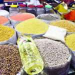
Economy-
The economy of Netrakona District is predominantly based on agriculture, which employs a majority of the population. Main crops include:
- Rice
- Jute
- Mustard
- Vegetables
- Sugarcane
Fisheries and livestock also contribute significantly to the local economy. In recent years, small-scale industries such as weaving, handicrafts, and food processing have emerged. The local markets are vibrant, offering a range of agricultural produce and handmade products.
Additionally, remittances from overseas workers have played a growing role in the district’s economy.
Education-
Netrakona District has made significant strides in the field of education. Key educational institutions include:
- Netrakona Government College
- Birishiri Mission Girls’ High School
- Netrakona Govt. Girls’ High School
- Mohanganj Degree College
- Kendua Pilot High School
The district also has several madrasas and vocational training centers. Though urban education is relatively advanced, rural and tribal areas still face challenges such as inadequate infrastructure and teacher shortages.
Healthcare
Healthcare facilities in Netrakona District are growing, though gaps remain. There is a District General Hospital in Netrakona town and Upazila Health Complexes in each upazila. Several private clinics and NGOs, such as BRAC and Red Crescent, supplement public health services.
Health indicators like maternal and infant mortality have improved due to government and NGO interventions, but rural and tribal areas still need more focused healthcare delivery.
Communication and Transport-
Netrakona is well-connected via road and rail. The Netrakona-Mymensingh-Dhaka highway ensures fast road communication. Major bus services connect the district with neighboring areas. The Mohanganj Railway Station is a major terminal, offering direct trains to Dhaka like the Haor Express and Mohanganj Express.
The district also has a network of regional roads and boat routes, especially in the haor areas, which are navigable during the monsoon season.
Culture and Festivals-
Netrakona District has a rich cultural heritage. The influence of Garo, Hajong, and Bengali traditions makes local festivals colorful and unique. Notable cultural elements include:
- Folk songs and dances, especially in tribal regions
- Baul and Lalon songs in rural areas
- Traditional festivals like Garo Wangala (harvest festival)
- Pohela Boishakh and other Bengali festivals
The district is also known for traditional crafts such as weaving and bamboo work.
Places to Visit in Netrakona-
Netrakona is home to several scenic and historical tourist spots:
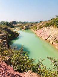
- Birishiri: Located in Durgapur, famous for its China Clay hills, Garo villages, and the Someshwari River. It is one of the most visited natural attractions in the district.
- Bijoypur China Clay Mine: Stunning white clay hills offering breathtaking views.
- Durgapur Tribal Cultural Center: Promotes the heritage of the Garo and Hajong communities.
- Haor areas in Mohanganj and Khaliajuri: Ideal for boating and birdwatching during the monsoon.
- Tomb of Shah Sultan Rumi: A Sufi saint’s shrine located in Netrakona Sadar.
- Ubinig Agro-Ecology Farm: A sustainable farming initiative popular among eco-tourists.
Notable Personalities from Netrakona-
- Nirmalendu Goon – Renowned poet and author
- Mustafa Kamal – Former Chief Justice of Bangladesh
- Dilip Barua – Politician and freedom fighter
- Bijoy Sankar Barman – Poet and cultural activist
These individuals have contributed immensely to literature, politics, and public life.
Climate-
Netrakona has a tropical monsoon climate, characterized by hot and humid summers, heavy monsoon rains, and mild winters. The monsoon season (June to September) brings most of the annual rainfall, flooding the haor regions and creating temporary water bodies. These support unique ecosystems and attract migratory birds.
Challenges and Development-
Like many other districts in Bangladesh, Netrakona faces development challenges, including:
- Riverbank erosion
- Lack of modern healthcare facilities
- Unemployment in rural areas
- Inadequate urban infrastructure
However, the government, NGOs, and international partners are working to improve education, health, women’s empowerment, and disaster resilience in the district.
Final Words-
Netrakona District is a blend of natural beauty, cultural richness, and historical depth. From the scenic hillocks of Birishiri to the colorful tribal festivals, the district offers a unique experience that reflects Bangladesh’s diverse identity. With continued development and preservation of its cultural heritage, Netrakona holds immense promise for the future.
FAQs (Frequently Asked Questions)-
Q: Where is Netrakona District located?
A: Netrakona District is located in the north-central part of Bangladesh, within the Mymensingh Division, and borders the Indian state of Meghalaya.
Q: What are the top tourist attractions in Netrakona District?
A: Birishiri, Someshwari River, China Clay Hills, Durgapur Tribal Culture Center, and the haor areas of Mohanganj are top attractions.
Q: What is the main economic activity in Netrakona?
A: Agriculture is the primary economic activity, along with fishing, handicrafts, and small industries.
Q: Which tribes live in Netrakona District?
A: The Garo and Hajong tribes are the major indigenous communities living in the northern areas of Netrakona.
Q: Is Netrakona connected to Dhaka by train?
A: Yes, trains like Haor Express and Mohanganj Express connect Netrakona to Dhaka via Mohanganj Railway Station.
Q: When did Netrakona become a district?
A: Netrakona was declared a separate district on January 1, 1984.